The Beginning of a Discovery
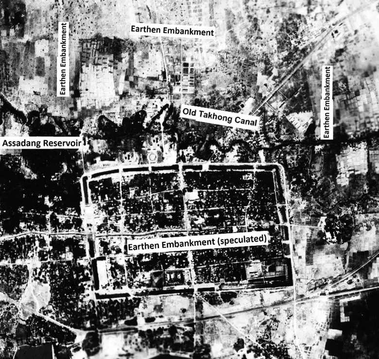
A research project headed by Prof. Dr. Santi Pailoplee from the Department of Geology, Faculty of Science, Chulalongkorn University, titled "Synthesis of Geoinformation and Statistics of Ancient Moats in Northeastern Thailand" has led to the discovery of evidence of an ancient earthen embankment around the old city of Nakhon Ratchasima, Muang District, Nakhon Ratchasima Province. These traces may indicate the existence of ancient communities before the construction of the old moat in Nakhon Ratchasima during the reign of King Narai the Great in the Ayutthaya period (B.E. 2199-2231).
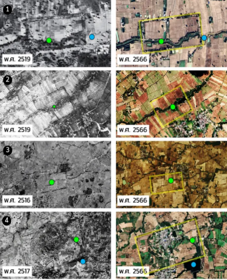
This discovery is a result of surveying and interpreting aerial photographs taken in 1954 by the Royal Thai Survey Department. Prof. Dr. Santi found that geographically, the area surrounding the old city of Nakhon Ratchasima was a floodplain of the Old Takhong Canal, which flows from Lam Takhong in the west, passing through the northern part of the city moat. This area is currently densely populated.
However, when examining the aerial photographs taken in 1954, Prof. Dr. Santi discovered what appeared to be an earthen embankment that extended continuously in a straight line to the north, west, and east of the Old Takhong Canal. This led to the interpretation that the embankment might be the boundary of another ancient community north of the old city of Nakhon Ratchasima, which was clearly surrounded by a square moat.
The Idea behind the Interpretation
Although the current condition of the area surrounding the old city of Nakhon Ratchasima has been significantly altered by present-day urban community activities, the interpretation of what is believed to be ancient earthen embankments, when considered together with the flow behavior of the Old Takhong Canal, shows that it does not follow the natural patterns of water movement. There are two geographical anomaly indicators:
- During the flood season, when water masses from the Old Lam Takhong flow in from the west and hit the earthen embankment on the western side (currently the Soi Prapa Road), the water is blocked by the embankment, causing flooding outside the embankment. Later, as all the water gradually flows through narrow channels left in the embankment for drainage, the water channels outside the embankment experience severe erosion. Sediments are carried along these channels more than in other areas, eventually creating lowlands that later developed into ponds or swamps in front of the embankment (currently the Assadang Reservoir).
- The large mass of water retained outside the embankment is forced by the embankment to flow through behind it at continuously high speeds. As a result, when the Old Lam Takhong enters the area behind the embankment (the ancient community area), it also experiences severe horizontal erosion, causing the stream to be more meandering than usual (more winding than typical streams). This is because the large volume of water that should flow evenly across the entire area is instead concentrated outside the embankment and is compressed and forced to shoot through only the Old Lam Takhong channel.
The survey of the earthen embankment shows that the embankment covered a rectangular area, with a clearly visible northern embankment stretching 2 kilometers. The length of the western and eastern embankments could not be initially assessed as the original embankments overlapped with the Nakhon Ratchasima city moat.
Based on the initial hypothesis that the southern boundary is Chompol Road, it can be concluded that the shape of this ancient community was something close to a square. This helps support another perspective that this earthen embankment is not a baray (a large water reservoir in ancient Khmer culture), which was typically rectangular in shape with a width:length ratio of approximately 1:2 in almost all cases.
Furthermore, from measuring the area's dimensions of 2 kilometers wide x 1.7 kilometers long, it can be calculated that this community had an area of 3.4 square kilometers or equivalent to 2,125 rai. This is considered a large community—twice the size of the old city of Nakhon Ratchasima and larger than other ancient communities mentioned above.
From this discovery, Prof. Dr. Santi Pailoplee commented that this is only a preliminary study based on remote sensing data, which will require additional archaeological surveys and excavations in detail to verify the accuracy of this interpretation. However, he hopes that these interpretative findings will serve as an initial guideline for archaeological research in the area and inspire the people of Nakhon Ratchasima Province to take pride in their great and long-standing local history.
Read the full article at https://www.chula.ac.th/en/news/221730
"Chulalongkorn University sets the standard as a university of innovations for society and is listed in the World's Top 100 Universities for Academic Reputation, in the Quacquarelli Symonds (QS) World University Rankings 2021-2022."